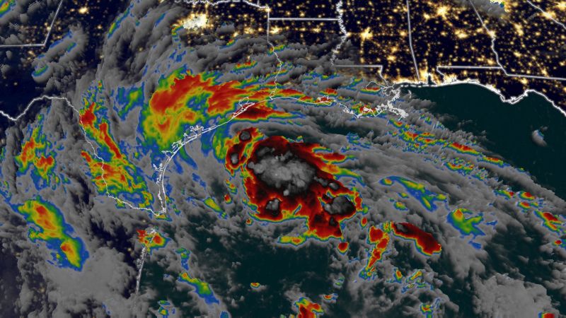
A tropical depression in the Gulf of Mexico has strengthened into a tropical storm as it continues to churn toward South Texas, where residents were bracing for heavy rain, flooding, powerful winds and dangerous rip currents Tuesday.
Tropical Storm Harold had maximum sustained winds of 45 mph around 2 a.m. ET Tuesday, when its center was about 195 miles east-southeast of Port Mansfield, Texas, the National Hurricane Center said. More than 1 million people are under tropical storm warnings.
Heavy rain and tropical-storm-force winds are expected over parts of South Texas Tuesday morning, and the latest track has the system making landfall south of Corpus Christi by midday.
The storm, which formed as a tropical depression in the Gulf of Mexico late Monday afternoon, is expected to dump 3 to 5 inches of rain – and up to 7 inches in some areas – across South Texas on Tuesday and Wednesday. Across Mexico, 4 to 6 inches of rain are expected.
Tropical storm conditions are expected, with winds of 40 to 50 mph lashing the region and rising waters moving inland from the shoreline and bringing floods, forecasters said. Storm surge of 1 to 3 feet is expected along the mouth of the Rio Grande to Sargent, Baffin Bay, Corpus Christi and Matagorda Bay.
Life threatening surf and rip currents conditions are expected across Southern Texas Tuesday, and it’s possible the state will also see multiple tornadoes.
“The deepest water will occur along the immediate coast near and to the north of the landfall location, where the surge will be accompanied by large waves,” the hurricane center said.
South Beach and North Beach were closed for driving and camping Monday in anticipation of the storm’s arrival, Padre Island National Seashore officials said. The national seashore is located along a barrier island south of Corpus Christi.
Tropical storm warnings have been issued from the mouth of the Rio Grande to Port O’ Connor, Texas, with tropical storm watches in effect from Port O’Connor to Sargent, Texas.
Texas Gov. Greg Abbott deployed the Texas National Guard, swift water rescue boat squads, among other emergency resources ahead of the storm’s arrival. “Texas stands ready to deploy all available resources to South Texas as tropical storm conditions impact the region this week,” he said in a statement.
“I encourage Texans to remain weather-aware and heed the guidance of state and local officials and emergency management personnel as they work together to keep communities safe,” the governor added.
The storm threat is moving into southern Texas as the region continues to battle one of its hottest, driest summers on record.
While this tropical system’s rains could help quench parts of the drought-stricken state, some of the worst drought conditions – areas of extreme and exceptional drought in Central Texas – might miss out on much of the rain.
Corpus Christi officials told residents who must be outside during the incoming storm to drive slower than usual, turn on their headlights and be aware of possible flooding in low-lying areas.
Crews across the Corpus Christi area could be seen working Monday to prep critical canals and drainage infrastructure for the heavy rainfall.
About 40 miles northeast, the city of Port Aransas has declared a local state disaster on Monday ahead of impacts from the storm.
The city is “under the threat of imminent disaster, injury, or loss of life or property, resulting from a Tropical Storm, which will impact the coastal beaches of the City of Port Aransas Nueces County, Texas with flooding or severe damage,” the proclamation said.
Naval Air Station Kingsville ordered those in the RV Park on the installation to evacuate, while voluntary evacuations were called in Riviera, Baffin Bay and Loyola Beach, authorities said.
Meanwhile, AEP Texas, which delivers power to South Texas, said it is lining up crews, equipment and other resources in anticipation of possible power outages.
The system headed to Texas is the latest sign the Atlantic hurricane season is ramping up. Three tropical systems formed in 24 hours Saturday into Sunday, and the Texas storm marks the fourth.
On Sunday, Tropical Storm Hilary made landfall in Mexico before crossing into California, knocking out power, turning streets into raging rivers and forcing evacuations and water rescues.
Conditions in the Gulf of Mexico are ripe for tropical development. Sea surface temperatures in the Gulf of Mexico are warmer than they’ve ever been on record, according to analysis of NOAA data by hurricane expert Michael Lowry.
Two tropical storms are lined up in the Atlantic Basin, including Tropical Storm Franklin, which is set to impact Hispaniola by mid-week.
Franklin’s center had sustained winds of 50 mph as of 11 p.m. ET Monday, located over the Caribbean about 275 miles south of Santo Domingo, Dominican Republic. It is expected to make a hard turn to the north by Tuesday morning and make landfall in Hispaniola Wednesday.


