Major Hurricane Lee will continue to grow in size after a crucial northward turn midweek which will determine the extent and severity of its impact on the Northeast, New England, Bermuda and Canada.
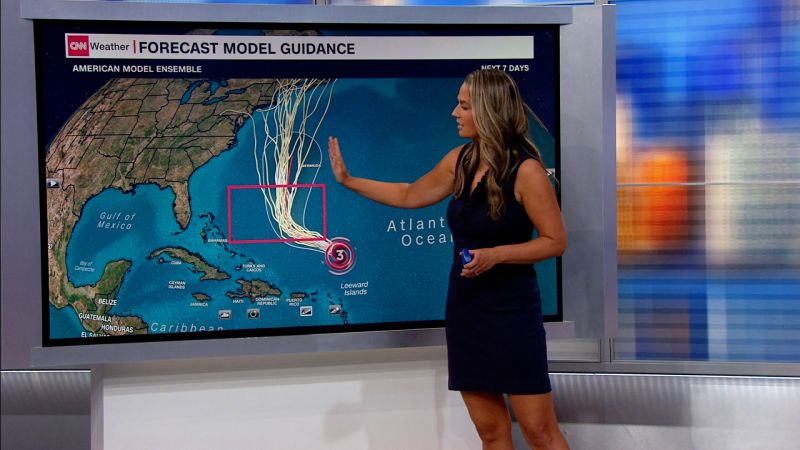
Lee was a Category 3 hurricane on Monday, located well north of the Leeward Islands and Puerto Rico in the Atlantic Ocean with maximum sustained winds of 115 mph, according to the 5 p.m. ET update from the National Hurricane Center. It is expected to weaken, grow in size and speed up after it makes its northward turn in the coming days.
Although it may be weaker, a larger storm has the potential to impact a more widespread area, increasing the likelihood that Lee will affect the Eastern Seaboard – even it’s not in the form of a direct landfall.
“Even as the peak winds come down, the wind field of Lee is going to continue to grow in size,” National Hurricane Center Director Michael Brennan said in a Monday storm briefing. “We could see the tropical storm-force winds expand by 50 to 60 to 70%.”
As of Monday, hurricane-force winds extended 75 miles from Lee’s center, up from 45 miles on Sunday. Tropical storm-force winds extended 185 miles from its core. Those tropical storm-force winds could extend over 300 miles from Lee’s center later this week, Brennan said.
“There’s still a lot of uncertainty as to the exact track of how close it will get to the coast of New England and Atlantic Canada over the next several days,” Brennan said, “but certainly the chance for significant impacts with a growing storm.”
Lee’s exact track, even if it stays off the coast of the US, will be crucial. The storm’s the large wind field means that oscillations east or west will affect the storm’s severity on land. Even if Lee stays a couple hundred miles off the coast, it could still lash the coast with strong winds, rain and coastal flooding.
The final track of the storm after it passes by Bermuda on Thursday or Friday remains highly uncertain because its current slowdown is also delaying key forecast details. Exactly when, where and how fast Lee makes its northward turn will determine how close it tracks to the East Coast on its nearest approach over the weekend – details that could come more into focus as soon as Wednesday.
If Lee tracks farther to the west before its northward turn, areas north of the Carolinas – particularly eastern New England and Atlantic Canada – could be more at risk of rain, wind and coastal flooding. If the storm turns more abruptly, it would track more to the east and lessen the risk to the entire Eastern Seaboard.
Bermuda could be spared a direct hit, but may still experience strong winds and heavy rain as Lee tracks just to its west. Brennan said watches could be issued for the island as soon as Tuesday.
Regardless of its final track, the storm will send big waves to a growing area of the East Coast throughout the week as it tracks northward off the coast. This will cause coastal erosion, dangerous surf and life-threatening rip currents at beaches.
Dangerous surf was already happening along the Florida coast and on many of the far eastern Caribbean islands as well as the British and US Virgin Islands, Puerto Rico, Hispanola, the Turks and Caicos, the Bahamas and Bermuda.
Rip currents have already killed 71 people in the US this year, preliminary National Weather Service data shows. Three people in New Jersey died in rip currents kicked up in the wake of Hurricane Franklin last week.
Lee, which was a Category 1 storm Thursday, intensified with exceptional speed into rare Category 5 status as it moved west across the Atlantic, more than doubling its wind speeds to 165 mph in just a day.


